
Monday, November 26, 2012
And So We Wait
As I posted on my Long Trail blog, I was unable to complete my planned hikes this past summer due to injuries. This doesn't mean that my Colorado Trail aspirations are forgotten. I'm not sure when I'll get back to the trail, but I'm hoping it will be sooner than later.

Tuesday, July 10, 2012
Breakdown of the Shakedown
 |
| Typical Sight Along the Trail |
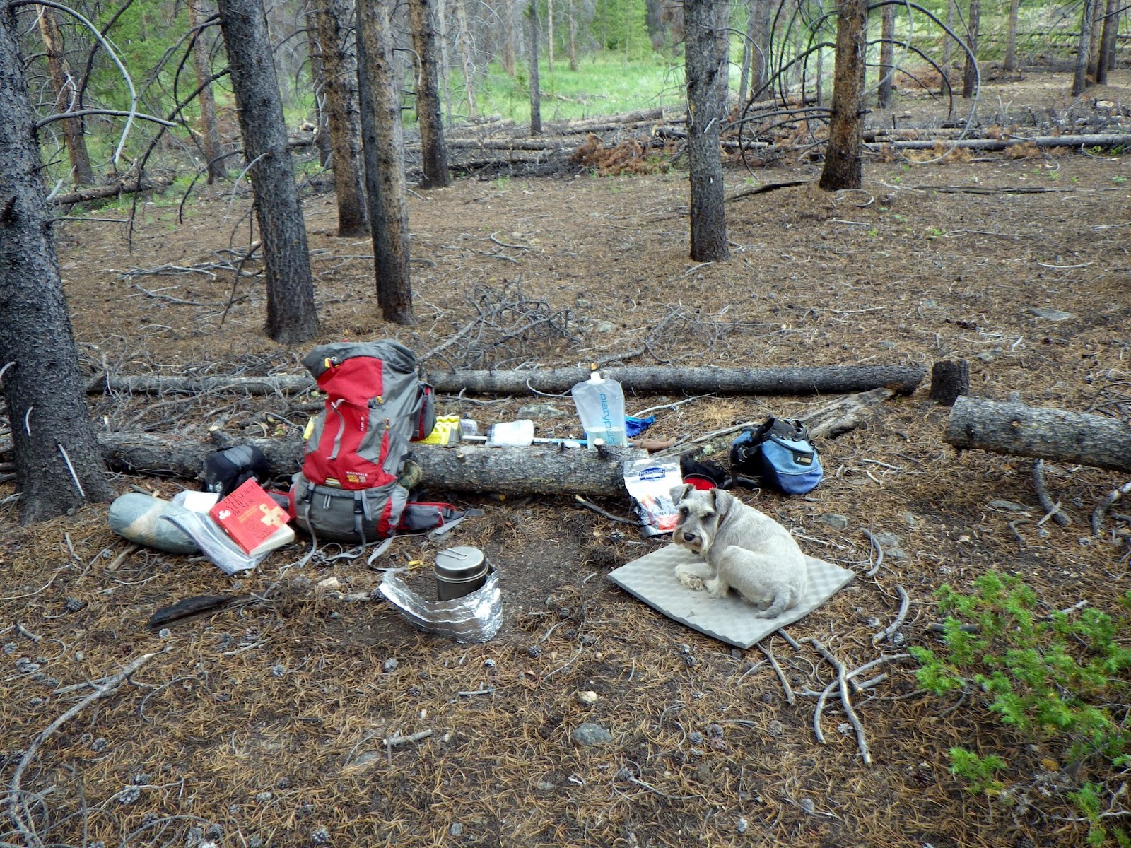
Gear Selections
Going into this hike, I had the following gear list:
This list represents a moderate improvement over the gear that I carried on the Long Trail - specifically, I reduced the base pack weight by about 2.33 pounds. I removed a few things (e.g., trail towel, water filter, etc), switched some things into Ramius' pack (e.g., his jacket), and added even more (e.g., Aquamira, a fuel bottle, etc.).
 |
| Photo from Big Agnes' Website |
 |
| Ramius Sleeping in the Shade (Vermont) |
 |
| Photo from Mountain Hardwear's Website |
I wanted to comment briefly about the switch from a water filter to Aquamira: it was a discerning and necessary choice. Sure, there are some issues associated with the use of chemical purifiers rather than a water filter (e.g., cloudy water, 30 minute waiting time, etc), but saving over a pound in weight made my hike so much more enjoyable. I had no trouble getting water into the Platypus and didn't detect any distinct chemical taste. Ramius was even willing to drink it - surprising only because he is sometimes very picky about his water sources.
Trail Performances
This trek was a hard one for three main reasons: we're out of shape, the sun is ever present, and we consumed water faster than we could find it.
 |
| Following Cairns at ~12,500 ft. |
In any case, I think that after a few 14ers we'll be well enough acclimated to the average elevation (10,000 ft) of the CT. One of the many things that I realized about myself and Ramius when we tackled a total of 7 peaks in as many weeks during the late summer of 2010 is that the first one is quite hard and the rest get progressively easier.
 |
| Feeling the Heat |
Goals and Expectations for the Future
Perhaps the best way to sum up the experience we had on the LT is to (loosely) quote the Stones: you can't always get what you want but, sometimes, you get what you need. That trip taught me that all the planning, training, and optimism doesn't get you anywhere when random events occur. Thus my hiking philosophy has changed to something closer to that of Kolby Kirk's billy goating. The term has been defined by Kolby as the following:
Billy Goating
noun
The act of hiking a long trail, such as the Pacific Crest Trail or the Appalachian Trail, simply for the enjoyment of being outdoors. The desire to enjoy the trail outweighs the motive of thru hiking. This definition fits between thru hiking, which is the act of hiking an entire trail from end to end, and section hiking, which is the act of hiking a defined section of a long trail. Billy goaters might start as thru hikers, but as their journey progresses, their intentions change from the act of getting somewhere to the act of enjoying where they are.
Examples:
“I’m going to billy goat the Sierra Nevada Mountains this summer. I have a general itinerary, but really hope to find some new areas to explore.”
“I’m currently billy goating through Maine’s 100-Mile Wilderness, hiking a few trails in the area.”
“I’m going to billy goat the Sierra Nevada Mountains this summer. I have a general itinerary, but really hope to find some new areas to explore.”
“I’m currently billy goating through Maine’s 100-Mile Wilderness, hiking a few trails in the area.”
So, while I would love to finish the trail as a proper thru-hike, I'm not going to sweat it. I will be making no itineraries. I will be setting no strict time-frames. I am not even going to reaffirm my commitment to bag the 14ers that I previously listed on this blog.
The goal of this endeavor is simple: pure and utter enjoyment of the trail.

Saturday, July 7, 2012
Shakedown Hike
After nearly a full month off of the trail, I came to realize two things: my leg wasn't hurting anymore from the accident in Vermont and I had been going stir-crazy. It was time to get back out on the trail.
So with that in mind and the 4th holiday fast approaching, I decided that Ramius and I should head out and explore a portion of the Colorado Trail. There were many things I would've liked to have known about the Long Trail prior to starting it for a thru-hike; thus I wanted to use this trip to get a better feeling for the trail and for my reduced gear. The plan was originally to hike a full quarter of the CT (segments 1-7), but this goal slowly changed over the course of the first day and was completely scrapped on day two. This was partially due to time and partially due to a desire on my part to remain healthy. In any case, I have posted a slew of videos, a few choice photos from each of the two days, and hiking stats from each day.
Day 1 - July 1, 2012
We arrived at the west end of segment 7 to 9:30am. The West end of segment 7 is located near Copper Mountain Ski Resort along highway 91. We quickly hopped out of the car and started up the trail. The first half-mile or so of the trail runs parallel to a creek that runs North-South before crossing the stream and turning back on itself. Along this path we encountered a number of thru-hikers and a lone mountain biker.
About 120 miles in 4 days was extraordinarily ambitious considering my recent leg injury, and it should be noted that I was under the impression I would have 5 days to complete that mileage until about 20 minutes before I made that video. It was something that I just decided to take in stride and roll with as I continued on my way toward highway 9.
Vermont's Long Trail was amazing to hike along, is a beautiful trail, and I wish we'd been able to continue through its entirety. I genuinely enjoyed the lushness of the trail and its surroundings and the wet conditions that made it extraordinarily easy to find drinking water. I cannot begin to describe how shocked I was that I literally never had to worry about finding the next spring or stream and that I didn't have to worry at all about water conservation for me and Ramius. That said, I'm a Colorado Native. I've been exploring Colorado's mountains, lakes, and trails since I could walk. Segment 7 epitomizes the types of terrain that I love and made me ecstatic to be back hiking in the high country that I love so much.
After enjoying the view of Copper, Ramius and I continued above treeline and simply enjoyed the views. We crossed paths with a few hikers - mostly day hikers at this point - and I greatly appreciated the encouragement handed out that we were 'nearly to the top.' I know that many hikers have a bittersweet relationship with such encouragement as it can ring somewhat hollow, but since both Ramius and myself were in the process of acclimating to the altitude after nearly a month at sea level I reveled in those few heartening words. The views to the East at the top of a ridgeline were simply gorgeous - valleys and mountains covered in pines, jagged rocks poking out of the mountainside, and gently sloping hills of grassy tundra above the treeline.
As we gradually descended from that ridgeline, we began to run into the first few thru-hikers of the day. Of note was a guy, about my age, named Kyle who described a significant amount of segments 1-6 for me. It seems that the second section is even more dry than anticipated in the guide - that is even the one place that is deemed to have a high chance of water is dry this year. I can't say this surprised me due to all of the high profile fires in Eastern Colorado this year. He also mentioned that segment 7 is where the going first starts to get tough in terms of elevation gain. Segment 6 has a fair amount of elevation gain and loss, but apparently it is more gradual than what he was experiencing heading West along that portion of the trail. He was slackpacking when I met him (i.e., he had only water and a little food) since he had to wait until the next day to pick up a package of provisions from the post office. We chuckled about his improvised gear setup and shared a moment thinking about how lucky we were to be taking such an adventure before parting ways.
This trend of stopping for 5 or so minutes to chat each time I passed a thru-hiker or mountain biker continued all the way down to highway 9. I gained some valuable information about water availability and alternate trails that we might enjoy seeing (this advice of course came exclusively from mountain bikers since an extra mile or two means very little to them). At one point Ramius and I literally stumbled into a group of thru-hikers that were having lunch in a rocky outcropping. We'd clambered up to the rocks and I was about to hop down from a ledge when I realized I'd be jumping right onto a backpack. The group of 4 had decided to link up for the day and were enjoying their lunches while taking in the spectacular views. We chatted for about a half hour and prepared a quick snack for me and Ramius - summer sausage and kibble for him and GORP and chocolate for me. We discussed similar things to what Kyle and I did, but in more detail. We exchanged trail names - they were Duke, Got Here Yesterday, Blondie, and Hershey's. I introduced Ramius and I by our trail names for the first time in Colorado - "I'm Boone, and this guy here is The Goon." This, as always, was greeted with laughter at Ramius' name. After a while we decided to head on - we were less than 10 miles in at this point. We wished our new friends the best of luck and gave them encouragement for their upcoming climb, then headed happily down the trail.
It took us another two hours or so to get to highway 9, and when we did I refilled our water for the third time that day. The heat was simply brutal. Keep in mind that it was only about 80 degrees up in Summit County, but it was clear to me that neither Ramius nor I had fully acclimated to Colorado's climate. We took a half hour break while the Aquamira did its magic, drank a full 3L between the two of us, refilled the Platypus, and headed into segment 6. It is notable that segment 6 is the longest segment in the first quarter of the CT at just around 32 miles total. The plan was to complete at least half of the segment before going to sleep for the night. This put us at about 30 miles for the day, and I felt good about it going into the segment.
The Western end of segment 6 is quite exposed to the sun. Because shade was so sparse, I decided to carry Ramius' pack for him in order to increase the distance he could travel and he seemed to perk up immediately. Well, it could have been that or the frequent stops we were forced to make as mountain biker after mountain biker after mountain biker came rumbling down the trail. I'm pretty tired of them, even writing this a week afterward.
As we continued along with little water, I became resolute that we hike until the next water source, where we would make camp. Alas, the CT Data Book misled me. Perhaps it is more accurate to say that I'd become quite comfortable relying on its ability to accurately indicate when and where we would find a water source. About 8 miles in, it became clear that we would need to continue for at least another 6-8 miles in order to find water. So we trudged on despite fading light and fatigue.
Eventually, as night began to fall, I gained a second wind after seeing a cluster of 14ers that I'd previously climbed: the infamous Decalibron. Consisting of Mount Democrat, Mount Cameron, Mount Lincoln, and Mount Bross, these peaks represented a previous challenge that I'd faced in the past. We pushed upward from the ridge that afforded that view and eventually came to a series of switchbacks that were to bring us to about 11,000 feet. Upon arriving at that elevation I decided that we needed to stop and eat. The elevation was getting to me after such a long day and I'd been trying to conserve our water as much as possible before getting to the next water source. After eating, I gave Ramius a good, long look and decided that we needed to stop for the day. This put our total day's mileage at about 24-25 miles. Our longest day in Vermont was about 20 miles, so I felt completely satisfied with this - especially after being off of my (and thus our) feet for a full month.
Ramius waited patiently as I set up camp on a ridge with a beautiful view of the setting sun to the West. We had some additional food - predominantly the moist summer sausage - and drank the last of our primary water. This left us with 0.5 liters of water for our morning hike. At this point I decided that it wasn't prudent to continue to push Ramius and myself as hard as I was with my injury and our lack of physical fitness. I resolved again to try to arrange a ride from between segments 2 and 3 in the morning. We slept without the rain fly, and woke up periodically to see the waxing moon shining high above us. If only we'd had the energy, it would have made a night hike simply marvelous.
Day 2 - July 2, 2012
After waking up we split the remaining water, made some phone calls about getting picked up somewhere near Jefferson, CO, and broke camp. Then, we headed West.
I began the hike knowing that things may not work out according to plan. Indeed, I'd just found out that we'd have 4 days instead of 5. I think this made our hike back to highway 9 much easier to accept and allowed me to enjoy the experience a heck of a lot more. And so we hiked around six or so miles back the way we'd come to the nearest water source. I have to admit that the way back seemed much, much, much longer than the way there. Perhaps this was due to the heat, our lack of water, or some combination therein, but I was ecstatic when I saw the power lines marking the gulch with a small stream running through it.
After gathering water, we needed to get back in the shade immediately, so we continued West for about a half hour before having a leisurely lunch of shepherd's stew, dog kibble, and (of course) summer sausage. I took a nap under a tree and Ramius joined in. I'll admit that I hadn't intended on taking so much time off to nap, but was happy that we did considering how quickly we made it back to highway 9. This put our total mileage for the day at around 11-13 miles. Once we made it there, I stopped to refill our water and we debated between remaining where we were until our pickup time or heading back to Frisco.
The weather made our choice for us and we ended up hanging out under a bridge. That's right: the Goon haunted the underside of a bridge for a number of hours. I read while Ramius slept, then I slept while Ramius slept, then I watched a small bird fish while Ramius slept... basically, Ramius was ready to be done for the day and I made use of my time in a number of ways. It eventually started raining, and we left the bridge due to the constant flow of water through its slats.
We found cover in a nearby bus shelter and waited another half hour or so before our ride picked us up. I spent the next couple of hours having an idle conversation, but my mind was still on the trail and dying to explore those places we weren't able to get to on this trip.
 |
| Typical CT Marker |
Day 1 - July 1, 2012
We arrived at the west end of segment 7 to 9:30am. The West end of segment 7 is located near Copper Mountain Ski Resort along highway 91. We quickly hopped out of the car and started up the trail. The first half-mile or so of the trail runs parallel to a creek that runs North-South before crossing the stream and turning back on itself. Along this path we encountered a number of thru-hikers and a lone mountain biker.
Introduction to Our Trail Goals
Taking in the View
 |
| Hiking a High Ridgeline |
 |
| Ramius Waiting Patiently |
 |
| Greenest Part of Our Day |
 |
| Typical Stretch of Trail in Segment 6 |
The Western end of segment 6 is quite exposed to the sun. Because shade was so sparse, I decided to carry Ramius' pack for him in order to increase the distance he could travel and he seemed to perk up immediately. Well, it could have been that or the frequent stops we were forced to make as mountain biker after mountain biker after mountain biker came rumbling down the trail. I'm pretty tired of them, even writing this a week afterward.
The Day's Realities Set In
As we continued along with little water, I became resolute that we hike until the next water source, where we would make camp. Alas, the CT Data Book misled me. Perhaps it is more accurate to say that I'd become quite comfortable relying on its ability to accurately indicate when and where we would find a water source. About 8 miles in, it became clear that we would need to continue for at least another 6-8 miles in order to find water. So we trudged on despite fading light and fatigue.
 |
| The Decalibron and Quandary at Sunset |
 |
| View of Sunset from our Camp |
Day 2 - July 2, 2012
Waking Up... Slowly
Accepting the Change in Plans
Sweet Water! (also, apologies for showing so much of Ramius' junk)
 |
| Lunch Time |
 |
| Killing Time |
Rain!
Friday, November 11, 2011
A Bit of Serendipity

But today, sleep deprived and mentally drained, I stumbled across Lefty's Colorado Trail Grille located in DIA's A Concourse. I couldn't help but smile as I thought about the adventures awaiting me and Ramius next summer.
A small update on trip progress:
- Recently purchased and tested Mini-Trangia 28-t stove
- works very well if you have time (~7.5 minutes to boil)
- Found a great store off of Canyon and 13th that will sell me maps at a discount
- Discovered a way to get Ramius up in Boulder with me more often so we can condition for our two 2012 walks

Saturday, September 10, 2011
The Plan, Man
Well, it has been nearly two months since my first post and a lot has happened in that time:
- 90% of the route is planned
- Found a great route to test gear on
- Financials are set
- Have a rough timeline for summer 2012
---------------------------------------------------------------------------------------------------------
I have the vast majority of the route planned out along with the logistics of getting my car to Durango before I actually leave. As of now, I'll be mostly sticking to the main trail with the exception of 12 Fourteeners, the Lost Creek Wilderness High Route, and Missouri Gulch. The Fourteeners will include Mt. Massive, Mt. Elbert, Missouri Mountain, Mt. Oxford, Mt. Belford, Mt. Harvard, Mt. Columbia, Mt. Yale, Mt. Princeton, Mt. Antero, and Mt. Shavano of the Sawatch Range and San Luis Peak of the San Juan Range. Needless to say, I am extraordinarily excited for the sheer level of peak bagging that will happen next summer - especially considering how the lack of a car severely limited my ability to get up to any Fourteeners this past summer. I will eventually post a GoogleEarth file on here with the exact route I plan on taking.
The route that I found to test gear on is located near the Flatirons and just a mile west of my home in Boulder. Including traveling to and from the trailhead, it is a 12-mile loop and offers a variety of terrain, trail grades, and exposure levels. I'm looking forward to using it more often once my gear starts flowing in.
Speaking of gear flowing in, I've got a financial plan to get all of my gear by late spring of 2012. I figure that this will give me plenty of time to test it out and break it in. Thank goodness for REI and its no-questions-asked return policy... I expect to go through several versions of certain items.
And as for the 'Summer 2012 Timeline,' I've decided that we will be heading to Vermont as soon as graduation is over (Mid-May), then heading over to Boston for a quick visit (Late June-Early July), starting the Colorado Trail (Mid-Late July), and finally heading to the Pacific Northwest (Late August-Early September) to visit long lost chemistry pals.
Here's to hopin'!
Thursday, July 14, 2011
Here We Go!
I have long been interested in hiking The Colorado Trail. This interest has increased over the years, especially with my discovery of Colorado's Fourteeners over the past year. Even more, Ramius loves to hike and is getting up in years - he is about 3 1/2 now - and I want to do something fun with him before we can't anymore. Beyond that even, I'm eager to celebrate the successful (cross your fingers) completion of my Master's.
So we have elected to hike roughly 500 miles from Denver to Durango shortly after our trip to Vermont in the summer of 2012. We are also going to bag a few peaks along the way, including several of the Ivies and Colorado's crown jewel: Mount Elbert.
I'm hoping to use this blog to organize my own trip and, if someone happens to stumble upon it, give advice to people travelling along the trail in the future - especially those who are travelling with dogs. It's a shame that there aren't more guides detailing a dog-friendly excursion, but I guess that just makes it that much more of an adventure.
Cheers!
Subscribe to:
Posts (Atom)